Updated: May 2026
The Ultimate Scenic Helicopter Flight Path from Bali to Komodo
- It follows the volcanic Ring of Fire over Lombok and Sumbawa.
- It provides unparalleled views of coral atolls and marine life.
- It grants exclusive access to remote landscapes inaccessible from the ground.
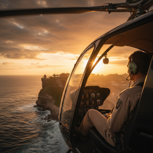
The whine of the turbine sharpens, the chassis shudders for a moment, and then, a sensation of impossible lightness. Below us, the intricate chaos of a Seminyak morning rush hour shrinks into a silent, moving mosaic. We ascend, banking east over the Sanur coastline, the aquamarine shallows giving way to the deep cobalt of the Lombok Strait. This isn’t merely a transfer. It’s an overture. The predictable hum of a commercial jet is replaced by the percussive beat of rotor blades, a soundtrack to an unfolding geographical epic. From the panoramic cockpit of our Airbus H130, the Island of the Gods is laid bare—a mix of emerald rice paddies, deep-cut river gorges, and the colossal, ever-present cone of Mount Agung, its 3,031-meter peak momentarily clear of its customary shroud of clouds.
The Departure: Crossing the Wallace Line from Bali to Lombok
As Bali recedes, the first act of our journey begins: the crossing of the Lombok Strait. This 35-kilometer-wide channel of water is more than just a gap between islands; it’s a profound ecological boundary known as the Wallace Line. As our chief pilot, Captain Adriansyah often remarks, “You can literally see the world change beneath you.” To the west, the lush, volcanic soil of Bali supports flora and fauna with Asian characteristics. To the east, Lombok’s landscape begins a subtle shift towards the drier, more Australasian climate that will define the rest of our flight. From our vantage point at 5,000 feet, the line is stark. The color of the vegetation shifts, the very texture of the land transforms. Below, the strong currents of the Indonesian Throughflow churn the strait, a vital artery for the world’s oceans. Within twenty minutes, the formidable silhouette of Lombok’s Mount Rinjani dominates the horizon. At 3,726 meters, it is Indonesia’s second-highest volcano, its vast caldera holding the crescent-shaped crater lake, Segara Anak. We arc around its southern flank, the aerial perspective revealing the scale of its 1257 AD eruption—an event so powerful it is believed to have influenced global climate for years.
A Triptych of Atolls: The Gili Islands from Above
Just off Lombok’s northwestern coast, three minuscule dots of white sand and coconut palms appear, each ringed by a halo of turquoise water. These are the Gili Islands: Trawangan, Meno, and Air. From the ground, they are a backpacker’s paradise. From the air, they are a lesson in coral reef geography. Our flight path allows for a slow, deliberate pass, revealing the intricate patterns of the fringing reefs. The dark patches of healthy coral stand in sharp contrast to the sandy bottoms, and on a clear day, you can even spot the shadows of sea turtles moving through the shallows. The largest, Gili Trawangan, shows its small network of paths, devoid of motorized traffic. Gili Meno, the quietest, reveals its saltwater lake, while Gili Air strikes a balance between the two. This aerial viewpoint underscores the fragility of these ecosystems, a perspective that informs the work of conservationists and is detailed by Indonesia’s official tourism board, indonesia.travel. It’s a fleeting, 10-minute spectacle that repositions these famous islands not as destinations, but as delicate jewels in a vast oceanic setting.
Sumbawa’s Volcanic Spine: An Untouched Geological Narrative
Beyond Lombok, we enter the flight’s most dramatic and sparsely populated chapter: the vast expanse of Sumbawa. This is where the true value of a private Indonesia helicopter charter becomes undeniable. The island, stretching over 280 kilometers, is a rugged and untamed landscape. Commercial flights cross it at 30,000 feet, rendering it a featureless brown smudge. We, however, trace its northern coastline at a few thousand feet, following the contours of a land forged by fire. The topography is a relentless series of volcanic calderas, dry riverbeds, and savanna-like grasslands that feel more African than Southeast Asian. The centerpiece of this raw spectacle is Mount Tambora. In April 1815, Tambora produced the largest volcanic eruption in recorded history, a VEI-7 event that ejected an estimated 160 cubic kilometers of rock and ash into the atmosphere, leading to the “Year Without a Summer” in 1816. From our aerial perch, the scale of its 6-kilometer-wide caldera is immense and humbling. Seeing it from this angle, you understand how a single geological event on a remote Indonesian island could alter the course of global history. This is the essence of the scenic helicopter flight path—it’s not just seeing, it’s understanding scale and context.
Moyo Island: A Fleeting Glimpse of a Royal Hideaway
Just off Sumbawa’s northern coast lies a small, verdant island that has long been a secret of the global elite. Moyo Island, a protected nature reserve, is a splash of brilliant green against the ochre tones of its larger neighbor. Its primary claim to fame is the ultra-exclusive Amanwana resort, which once hosted figures like Princess Diana. Our flight path takes us directly over the island’s interior, providing a rare glimpse of its famous Mata Jitu Waterfall. From the air, the waterfall is not a single cascade but a series of terraced limestone pools, their waters a startling shade of milky blue, hidden within a dense jungle canopy. This brief fly-over, lasting no more than five minutes, encapsulates the privilege of aerial travel. It offers a perspective on a place defined by its exclusivity, a view once reserved for its handful of discerning guests. You see the protected bays where phinisi schooners anchor and the pristine coral gardens that make it a premier diving location, all laid out in a single, comprehensive vista. It’s an insider’s peek, a moment of discovery before we continue our eastward trajectory toward the main event.
The Dragon’s Lair: First Contact with the Komodo Archipelago
The final leg of the journey is marked by a dramatic shift in the seascape. The deep blue of the Flores Sea begins to fragment, broken by a sudden explosion of islands. This is our arrival into Komodo National Park, a UNESCO World Heritage Site. The islands here are unlike anything we have seen before. They are primeval, with sawtooth ridges and arid, savanna-covered slopes that tumble down to brilliant white- and pink-sand beaches. The most iconic of these is Padar Island. While most visitors must undertake a strenuous 45-minute trek to its summit for the famous photograph, we see it as its architect intended. Our helicopter circles the island, revealing the tri-colored bay panorama in a single, fluid motion—one beach of volcanic black sand, one of powdery white, and one of crushed red coral that gives it a soft pink hue. We then sweep low over the coast of Rinca and Komodo islands, the ancestral homes of the Komodo dragon. From this height, the network of game trails used by the giant lizards, deer, and water buffalo is clearly visible, etching a story of predator and prey into the dry landscape. This is the most rewarding segment of the entire scenic helicopter flight path, a visual confirmation that you have arrived in a land forgotten by time.
Quick FAQ: Your Questions on the Bali-Komodo Helicopter Route
Navigating the logistics of a premier aerial journey requires clarity. Here are answers to the most common questions we receive from clients planning this exceptional experience.
How long is the scenic helicopter flight from Bali to Komodo?
The direct flight time is approximately 2 hours and 30 minutes, covering a distance of roughly 450 kilometers (280 miles). However, a true scenic tour, which includes orbits of key sites like Mount Rinjani and Padar Island, is best planned as a 3-hour journey to fully appreciate the landscape.
What is the best time of year for this flight?
The optimal window is during the dry season, from April to October. During these months, you’ll experience the clearest skies, minimal turbulence, and the most vibrant colors in the coral reefs below. The visibility is often in excess of 50 kilometers, ensuring unobstructed views of the volcanic peaks.
Can we land on any of the islands along the way?
Absolutely. The beauty of a private charter is its flexibility. With prior arrangement, we can coordinate landings on islands like Moyo or designated helipads in Sumbawa for a truly bespoke itinerary. These multi-stop journeys are a core part of our Indonesia Helicopter Tours & Charter services, allowing for a seamless blend of aerial sightseeing and ground exploration.
What type of aircraft is used for this route?
For this specific scenic helicopter flight path, we primarily utilize the Airbus H130 (formerly Eurocopter EC130). Its spacious, air-conditioned cabin and large, panoramic windows provide an exceptional viewing platform for up to 6 passengers, while its single-engine efficiency and safety record make it ideal for inter-island travel in the archipelago.
This journey is more than a transfer; it is the first chapter of your Komodo story, a narrative told from a perspective that few will ever witness. It re-frames the distance between two of Indonesia’s most iconic destinations not as an obstacle, but as a destination in itself. The flight transforms the map from a flat, two-dimensional guide into a living, breathing entity of volcanic power and marine delicacy. To experience this for yourself and to craft your own bespoke aerial adventure across the archipelago, explore the possibilities available with a world-class indonesia helicopter. Your ultimate journey begins the moment you leave the ground.