Updated: May 2026
A Helicopter Flight Over Indonesia's Volcanoes in the Dry Season
- Optimal Visibility: The dry season (May-September) ensures clear skies for unobstructed views of volcanic peaks.
- Exclusive Access: Reach remote and active volcanic landscapes like Semeru and Raung that are otherwise inaccessible.
- Unmatched Perspective: Witness the scale of calderas, the colors of acidic lakes, and the patterns of lava flows from a unique vantage point.
The air is cool, carrying the faint, clean scent of altitude. Below, the pre-dawn landscape is a mix of deep greens and volcanic soil, still cloaked in shadow. The rhythmic pulse of the Airbus H130’s rotor is a steady heartbeat as we ascend, climbing at a brisk 1,500 feet per minute. Then, it happens. The sun breaches the horizon, and the colossal cone of Mount Semeru catches the first light, its peak a stark, magnificent silhouette against the rapidly brightening sky. A plume of ash and gas drifts from its summit, a casual exhalation from the Earth’s core. This is not a postcard; it is a direct communion with one of the planet’s most dynamic forces, a moment that redefines your understanding of scale and time.
Why the Dry Season is the Definitive Time to Fly
As a travel editor, I am frequently asked about timing. For a helicopter flight over Indonesia’s volcanoes, the answer is unequivocal: the dry season, which typically runs from May through September, is the only period to consider. This isn’t a matter of preference, but of pragmatism and safety. During these months, the prevailing weather systems shift, reducing average monthly rainfall by as much as 80% compared to the wet season’s peak in January. This meteorological shift translates into consistently clear skies, especially during the crucial morning hours when atmospheric conditions are most stable. Visibility can extend for over 50 kilometers, transforming the flight from a mere tour into a grand, panoramic survey of the entire volcanic chain of East Java.
Conversely, attempting such a flight during the monsoon season (October to April) is fraught with challenges. Low-lying cloud cover can completely obscure the peaks, rendering the trip pointless. More critically, the interaction of heavy rainfall with volcanic ash creates a phenomenon known as ‘lahar’—a thick, cement-like mudflow—and in the air, wet ash can be corrosive and damaging to helicopter engines and rotor blades. Captain Adhitya, a veteran pilot with over 12,000 flight hours in the region, explained it to me last year. “In the dry season, the air is predictable. We can navigate the volcanic updrafts and assess gas plumes visually from a safe distance. In the wet season, the weather is a chaotic variable that introduces unacceptable risk.” The dry season provides a stable, reliable canvas upon which to witness this geological theater, ensuring both the quality of the experience and the paramount safety of everyone on board.
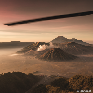
The Javanese Ring of Fire: A Geologist’s Dream Itinerary
Indonesia is the epicenter of the Pacific Ring of Fire, an arc of seismic and volcanic activity. The archipelago is home to 127 active volcanoes, more than any other country on Earth. An aerial expedition here is less a simple sightseeing trip and more a masterclass in geology. Our flight path began over the Bromo Tengger Semeru National Park, a landscape so otherworldly it feels lifted from a science fiction film. From our altitude of 10,000 feet, we could see the entire Tengger caldera—a vast, 10-kilometer-wide sea of sand—with the active cone of Mount Bromo steaming at its center. To the south, the undisputed king of Java, Mount Semeru, rises to an impressive 3,676 meters. This is Indonesia’s highest and most active volcano, and from the air, we could witness its regular eruptive cycle, a minor explosion of ash that occurs roughly every 20 minutes.
From Bromo, we flew east, a journey that maps the raw power of plate tectonics. We passed over Mount Raung, its 2-kilometer-wide caldera a stark, grey wound in the earth, a testament to a colossal past eruption. The final destination of our aerial survey was the Ijen volcano complex. While famous for the ethereal blue fire visible at night, its daytime aerial view is arguably more impactful. The crater holds the world’s largest highly acidic lake, a one-kilometer-wide body of water with a pH as low as 0.5. From the helicopter, the lake is a mesmerizing, almost unnerving, shade of turquoise. You can see the sulfurous vents staining the crater walls yellow and observe the faint trails of the sulfur miners who make a treacherous daily trek into this toxic environment. It’s a powerful reminder of the complex relationship between humanity and these volatile giants, a perspective only accessible when you see the whole picture from above. For a complete overview of the region’s volcanic wonders, the official indonesia.travel portal offers excellent ground-level context.
The Aircraft and the Crew: The Art of High-Altitude Navigation
A journey of this magnitude demands more than just a destination; it requires impeccable machinery and profound expertise. The choice of aircraft for volcanic exploration is critical. Our flight was aboard an Airbus H130, a helicopter I’ve come to trust on assignments from the Alps to the Andes. Its Fenestron tail rotor makes it one of the quietest in its class, reducing noise impact on the environment and allowing for clearer communication in the cabin. More importantly, its powerful Safran Arriel 2D engine provides the high-altitude performance necessary to safely operate around peaks that exceed 12,000 feet. With a service ceiling of 23,000 feet, the H130 has more than enough power in reserve to navigate the unpredictable mountain air currents and downdrafts common in volcanic regions.
However, the most advanced aircraft is only as good as its pilot. Navigating this environment is a specialized skill. It requires an intimate understanding of micrometeorology, vulcanology, and the specific “behaviors” of each mountain. The pilots contracted by premier services are not merely aviators; they are aerial guides and risk managers. They know which side of a crater is likely to have turbulence at a certain time of day and can interpret the color and dispersal pattern of a gas plume to assess its potential danger. Our pilot had logged thousands of hours specifically in this volcanic corridor. He provided a running commentary, pointing out historic lava flows, explaining the formation of the Tengger sand sea, and maintaining a safe, respectful distance from active vents, ensuring our presence was minimally intrusive and maximally secure. This level of professionalism is the bedrock of any true luxury adventure experience, transforming a potentially hazardous flight into a seamless and enlightening expedition. This is the standard of excellence you can expect from a top-tier indonesia helicopter service provider.
Beyond the Caldera: The Cultural Landscape from 5,000 Feet
While the volcanoes are the undeniable protagonists of this aerial drama, the supporting cast of landscapes seen from the air is equally compelling. A helicopter provides a unique macro-perspective, revealing the intricate patterns of human civilization and nature that are invisible from the ground. As we descended from the high volcanic plains, the landscape transformed. The stark, monochromatic world of ash and rock gave way to an intense, vibrant green. The slopes of the volcanoes, fertilized by millennia of ash deposits, are some of the most fertile lands on the planet. From our vantage point, we could see entire valleys carved into intricate terraces of rice paddies, shimmering like shattered mirrors in the morning sun. These patterns, sculpted by hand over centuries, speak to a deep, enduring relationship between the Javanese people and their volatile environment.
Further west, a slight deviation in our flight plan offered a glimpse of another wonder: the Borobudur Temple Compounds. Seeing this 9th-century Mahayana Buddhist temple from the air is a profound experience. The structure’s design as a giant three-dimensional mandala, a map of the cosmos, is only truly comprehensible from above. You can trace its nine stacked platforms, the square lower levels representing the world of desire, and the circular upper levels representing the world of formlessness. This UNESCO World Heritage site is a marvel of engineering and devotion, and the aerial view connects it to the surrounding landscape, with the twin volcanoes of Merapi and Merbabu looming in the distance as its spiritual guardians. These ancillary sights enrich the journey, framing the raw geology of the volcanoes within a rich cultural and agricultural context.
Crafting Your Bespoke Aerial Journey
The true hallmark of modern luxury travel is personalization, and an aerial expedition over Indonesia’s volcanoes is no exception. A standard tour is impressive, but a bespoke charter allows you to curate an experience that aligns perfectly with your specific interests, whether they are in photography, geology, or simply the pursuit of sublime moments. Working with a flight concierge, you can design an itinerary from scratch. Perhaps you are a photographer chasing the “golden hour.” A charter can be arranged for a pre-dawn departure, allowing you to be in position over Mount Bromo precisely as the sun rises, casting long shadows across the Sea of Sand. You can request to linger, circling the crater multiple times to capture the perfect shot from every angle.
Or maybe your interest is purely geological. An extended itinerary could include a flight over the Dieng Plateau, a volcanic caldera filled with multi-colored lakes, or a pass over the perpetually smoking Mount Merapi near Yogyakarta, one of the most active and dangerous volcanoes in Indonesia. The flexibility is remarkable. You can choose your departure point, your flight duration (from a 60-minute highlights tour to a half-day comprehensive expedition), and even request a landing at a remote luxury lodge for lunch. The premier Indonesia Helicopter Tours & Charter — National Network can tailor these complex logistics. These charters, which typically start from around $5,000 per hour depending on the aircraft and itinerary, represent the pinnacle of experiential travel, offering an intimate and unparalleled encounter with the archipelago’s fiery heart.
Quick FAQ: Your Questions About Volcanic Helicopter Tours Answered
What is the best time of day for a helicopter flight?
Early morning, without question. Departures are typically scheduled between 6:00 AM and 7:00 AM. This is when the air is coolest and most stable, providing the smoothest ride. It also offers the best light for photography and the highest probability of cloud-free views before the daytime convective heat begins to build cloud cover around the peaks, which often happens by late morning.
How safe is it to fly near active volcanoes?
Safety is the absolute top priority. Reputable operators use highly experienced pilots trained in volcanic environments and fly meticulously maintained, powerful turbine helicopters. They maintain a safe lateral and vertical distance from active craters and monitor real-time volcanic activity reports from agencies like the Indonesian Center for Volcanology and Geological Hazard Mitigation (PVMBG). Flights are immediately canceled or rerouted if a volcano shows any signs of heightened unrest.
What should I wear and bring on the flight?
Even in tropical Indonesia, it can be quite cold at altitude. It is advisable to wear layers, including a warm jacket or fleece. Wear comfortable, closed-toe shoes. For photography, a polarizing filter is highly recommended to cut through the atmospheric haze and manage reflections off the helicopter’s windows. Sunglasses are essential. Most importantly, bring a fully charged camera; you will be using it constantly.
Witnessing the elemental forces that have shaped, and continue to shape, our planet is a humbling and transformative experience. From the rhythmic breath of Semeru to the toxic beauty of Ijen’s crater lake, a helicopter flight over Indonesia’s volcanoes is one of the last great adventures. It offers a perspective that is both grand in scale and intimate in detail, a memory that will remain long after the sound of the rotors has faded. To plan your own aerial expedition and witness this extraordinary landscape for yourself, contact our flight specialists to book your indonesia helicopter adventure today.